HAWAIIAN VOLCANO OBSERVATORY STATUS REPORT
U.S. Geological Survey
Friday, December 9, 2022, 3:30 PM HST (Saturday, December 10, 2022, 01:30 UTC)
MAUNA LOA (VNUM #332020)
19°28’30” N 155°36’29” W, Summit Elevation 13681 ft (4170 m)
Current Volcano Alert Level: WARNING
Current Aviation Color Code: ORANGE
The Northeast Rift Zone eruption of Mauna Loa continues, with reduced lava output and gas emissions at fissure 3 (F3) since this morning.
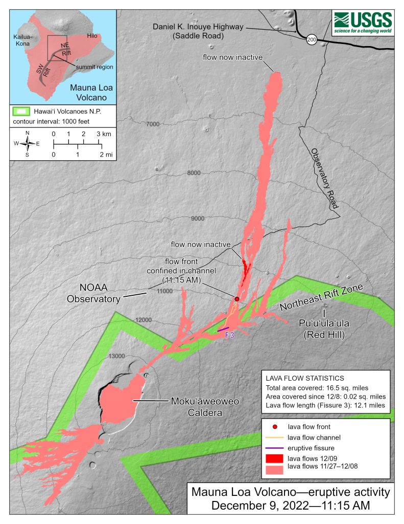
As of 11:30 a.m. today, December 9, activity at the F3 vent continues to be significantly reduced, with low lava fountains feeding lava flows that extend only 1.65 mi (2.65 km) from the vent in northeast direction. The channels below this point appear drained of lava and probably no longer feed the main flow front.
The inactive main flow front remains stalled about 1.7 mi (2.8 km) from the Daniel K. Inouye Highway (Saddle Road). Yesterday, December 8, the inactive main flow front inched northward very slowly about 7 feet (2 m) per hour as it settled.
Sulfur dioxide (SO2) emission rates were also reduced to approximately 30,000 tonnes per day (t/d) as measured on December 8, 2022. The Hawaii Interagency Vog Information Dashboard has detailed information about vog: https://vog.ivhhn.org/. Forecasts for the dispersion of vog can be found on the VMAP Vog Forecast Dashboard: http://weather.hawaii.edu/vmap/new/.
Tremor (a signal associated with subsurface fluid movement) continues beneath the currently active fissure. This indicates that magma is still being supplied to the fissure, and activity is likely to continue as long as we see this signal.
The significance of the reduced supply of lava is not yet clear; it is common for eruptions to wax and wane or pause completely. A return to high levels of lava discharge could occur and the Hawaiian Volcano Observatory continues to closely monitor this activity.
There is no active lava within Moku’āweoweo caldera nor the Southwest Rift Zone. We do not expect any eruptive activity outside the Northeast Rift Zone.
- Most recent eruption map: https://www.usgs.gov/media/images/most-recent-mauna-loa-northeast-rift-zone-eruption-map
- Information on lava viewing: https://hawaii-county-volcano-hazards-hawaiicountygis.hub.arcgis.com/
- The network connection for our streaming video of the fissure 3 fountains has been going in and out. If it is working, you can view it at https://www.youtube.com/usgs/live

